

|
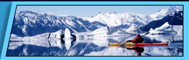
We offer Alaska raft trips that offer scenic views, wildlife viewing, fishing, and whitewater.
Custom group Alaska rafting adventures are available on request. If have interested in something special or participating in an exploratory expedition, please contact us with your ideals or to see what plans are being made.
Kongakut River - 10 day Arctic National Wildlife Refuge Rafting Safari. Explore Alaska's remote Arctic National Wildlife Refuge (ANWR) by raft on the "river of caribou". Our trip coincides with the annual migration of the 130,000-strong Porcupine caribou herd and passes through some of the world's most pristine wilderness.
Lake Creek - 7 day Whitewater Rafting and Fishing Adventure. Our favorite fly-in wilderness adventure river, great combination exciting whitewater and great Alaska fishing. Lake Creek offers almost continuous Class II/III whitewater with a few Class IV rapids, five species of salmon, rainbow trout and arctic grayling.
Chulitna River - 4 day Denali Raft Adventure. An excellent family adventure and sampling of Alaska's best wilderness and geography at a casual pace. We travel through Denali State Park, upper Susitna Valley and take out near Trapper Creek, a historic gold mining town. |
|
|
|
 |
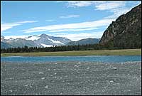
Kenai Fjords National Park
Bear Glacier Changes With Global Warming
U.S. Geological Survey Department of the Interior/USGS
Repeat Photography of Alaskan Glaciers
Repeat photography is a technique in which a historical photograph and a modern photograph, both having the same field of view changes with a glacier. The following depict a number of locations at Bear Glacier to document changes to glaciers.
Bear Glacier
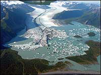
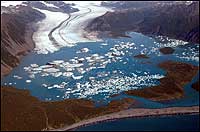
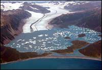
Three oblique aerial photographs that show changes in the terminus of Bear Glacier, Kenai Mountains, Kenai Fjords National Park, Alaska, during the five year period between 2002 and 2007. The September 2, 2002 oblique aerial photograph of is taken towards the north and shows the retreating, calving terminus of the glacier, located at the head of a large ice-marginal lake, informally named Bear Lake. Prior to 1950, the entire basin of Bear Lake was filled by Bear Glacier's piedmont lobe. By 1961, a small lake occupying less than 10% of the basin had developed adjacent to the southeast margin of the glacier. By 1984, the lake nearly doubled in size. In the 18 years between 1984 and September 2002, the lake quadrupled in size. The triangular-shaped terminus of the glacier depicted here has retreated at least 2 kilometers (1.2 miles) from its 1984 maximum position. The large tabular icebergs and the low relief, low-gradient terminus suggests that the terminus has thinned so much that much of its lower reaches are afloat. Floating glacier termini typically retreat rapidly and calve large tabular icebergs. (USGS photograph by Bruce F. Molnia). The second photograph was made on August 6, 2005. During the 35 months between photographs, the triangular-shaped terminus of the glacier retreating more than 3 kilometers (1.9 miles) with the large triangular lobe disappearing, the result of intensive passive calving. The glacier has also thinned by about 10 meters (33 feet). The large tabular icebergs that are present are evidence of the rapid disarticulation of the glacier's terminus. (USGS photograph by Bruce. F. Molnia). The third photograph was made on August 13, 2007. From 2005-2007, the terminus continued to retreat through passive calving, although at a slower rate than prior to 20005. A few of the large tabular icebergs are remnants of even larger icebergs present in 2005. Others are the result of continuing disarticulation of the glacier's western terminus. In the 24 months between images, the western margin of the glacier retreated more than 0.4 kilometers (0.25 miles). (USGS Photograph by Bruce F. Molnia).
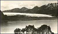
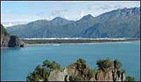
A pair of northeast-looking photographs, both taken from the same location on a ridge in Bulldog Cove, near Bear Glacier Point, Kenai Mountains, Alaska, shows changes to Bear Glacier between the early 1920s and 2005. The older photograph is from a postcard labeled Harding Glaciers, Resurrection Bay, Alaska. The water in the foreground is part of lower Resurrection Bay. The name Harding Glacier or Glaciers was never officially adopted for Bear Glacier. In 1923, President Warren G. Harding visited Alaska, including a trip to Resurrection Bay and nearby Seward. The name Harding Icefield was officially approved in 1950 for the upland accumulation area that feeds Bear Glacier and a number of other glaciers of the Kenai Fiords. When photographed in the 1920s, Bear Glacier's piedmont lobe was greatly expanded. Note that a few small shrubs or trees are present on the low sediment plain in front of the glacier's terminus. (undated, unnumbered postcard; unknown photographer, courtesy of Kenai Fjords National Park). The second photograph was made on August 12, 2005. In the approximately 80 years between photographs, Bear Glacier's piedmont lobe has retreated completely out of the field of view. Large icebergs, floating in the ice-marginal lake that fills the basin formerly occupied by Bear Glacier's piedmont lobe, represent the only glacier ice that is visible. Isolated patches of snow are present at a few higher elevation locations. Note the dense vegetation that has developed around the margin of the lake and on most of the lower gradient slopes. (USGS Photograph by Bruce F. Molnia).
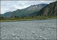
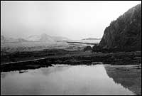
A pair of northeast looking photographs taken from the same location on the cobble backbeach south of Bear Glacier, Kenai Fjords National Park, Kenai Mountains, Resurrection Bay, Alaska. The first photograph by U.S. Grant, is a July 20, 1909 photograph of the eastern part of the terminus of Bear Glacier, fronted by a small outwash plain and several moraine ridges. When photographed, the glacier was slowly retreating. (USGS Photo Library - Photograph Grant 123). ). The second photograph dates from August 11, 2005. In the 96 years between photographs, Bear Glacier has retreated more than 3 kilometers (1.9 miles) and is no longer in the field of view. It has thinned by as much as 200 meters (656 feet). The sediment body in the foreground is often overtopped by storm waves, hence the driftwood log. The water in the middle of the photograph is part of the river that connects the large ice-marginal lake that has developed adjacent to the retreating terminus with Resurrection Bay. Note the abundant vegetation north of the river. (USGS Photograph by Bruce F. Molnia).
|
A pair of north looking photographs taken from the same location on the backbeach south of Bear Glacier, Kenai Fjords National Park, Kenai Mountains, Resurrection Bay, Alaska. The first photograph by U.S. Grant, is a July 20, 1909 photograph of the eastern part of the terminus of Bear Glacier, fronted by a small outwash plain and a small lagoon. When photographed, the glacier was slowly retreating. (USGS Photo Library - Photograph Grant 120). The second photograph dates from August 11, 2005. In the 96 years between photographs, Bear Glacier has retreated more than 3 kilometers (1.9 miles) and thinned by as much as 200 meters (656 feet). Only a very small part of Bear Glacier is visible. The tributary descending from the mountains was not visible in 1909 as it was hidden by the then massive terminus of the glacier. The lagoon present in 1909 has been filled with sediment and the outwash plain to the north is covered by grasses, wildflowers, shrubs, and trees. (USGS Photograph by Bruce F. Molnia).
Bear Glacier Wilderness Retreat
Related Bear Glacier Natural History Links
Bear Glacier Changes With Global Warming
Iceberg Sizes, Shapes And Classifications
Kenai Fjords Glaciers - Glacial Features
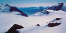
Harding Icefield
A Tour of the Life of a Glacier
 |
Backcountry Safaris
P.O. Box 1397 Seward, Alaska USA 99664
1-907-205-5900 • Fax 1-907-205-5902
 |
| |
|
Bear Glacier Tour Options |
|
Optional Tours And Upgrades |
|
Maps |
|
Related Links and Natural History |
|
|
Kenai Fjords Wildlife |
|
|
Kenai Fjords Birds |
|
Suggested Alaska Reading List |
|
Kenai Fjords Weather |
|
Current Seward, AK Weather |
|
 Did You Know? Did You Know?
The Harding Icefield accumulates 400-800 inches of snow each year. It takes between 30-50 years for that snow to compress into glacial ice. |
|