


|
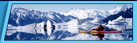
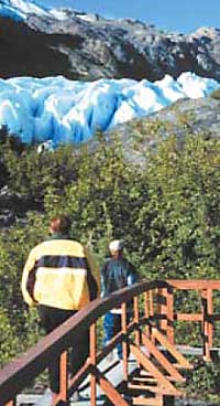
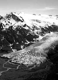
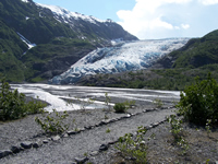
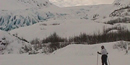
The Retreat of Exit Glacier by Susan Huse —biologist for the Alaska Support Office, National Park Service 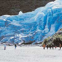 As thousands of visitors hike up the Exit Glacier valley this summer, they will benefit from work completed in 2001 by Joel Cusick, a mapping specialist for the National Park Service. His work has recreated the history of Exit Glacier’s movement over the last 200 years, using techniques such as aerial photography and tree coring to identify and date the extent of the glacier. His findings will help further biological research and park planning, and it will help visitors gain insight into the magnitude and the time scale of glacier movements. Scientists studying plant and soil growth in a glacial environment gain a chronology of the valley’s exposure, which helps determine when plants began to reestablish and the soil chemistry began its progression from glacial till to forest soil. As thousands of visitors hike up the Exit Glacier valley this summer, they will benefit from work completed in 2001 by Joel Cusick, a mapping specialist for the National Park Service. His work has recreated the history of Exit Glacier’s movement over the last 200 years, using techniques such as aerial photography and tree coring to identify and date the extent of the glacier. His findings will help further biological research and park planning, and it will help visitors gain insight into the magnitude and the time scale of glacier movements. Scientists studying plant and soil growth in a glacial environment gain a chronology of the valley’s exposure, which helps determine when plants began to reestablish and the soil chemistry began its progression from glacial till to forest soil.Kenai Fjords National Park Kenai Fjords National Park lies along the Kenai Peninsula coast in southcentral Alaska, just southwest of Prince William Sound. The park landscape is a dramatic juxtaposition of land and water, shaped by the advance and retreat of glaciers. The park is capped by the largest icefield entirely contained within the United States, Harding Icefield, a 300 square mile expanse covering a mountain range under ice several thousand feet thick. Exit Glacier is one of 38 glaciers that flow out from the Harding Icefield. During the early nineteenth century, the glacier almost reached the Resurrection River, approximately 1.25 miles (2 km) below its present location. In the last 200 years, the glacier retreated exposing the valley below. The exposed valley is a natural laboratory where we can see the processes of life reclaiming a barren landscape: moss, lichen and fireweed colonize the bare rock; followed by grasses, shrubs, alders, and cottonwood; and finally, a spruce-hemlock forest grows where 200 years ago only ice and rock existed. Exit Glacier is accessible by road and thousands of park visitors have an opportunity to experience the glacier firsthand. Understanding Glaciers
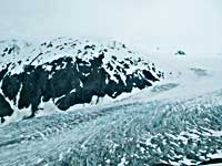
During a recession, the ice and rock continue to flow downhill to the toe of the glacier. As the ice melts, rock deposits are left on the ground in front of the leading edge of the glacier, glacial till. In this way a continuous layer of till is left across the 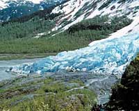 newly exposed valley floor. There are also periods when the ice at the front melts at essentially the same rate as the ice flows down. This is called a period of stagnation, and the front edge of the glacier stays in one place, neither receding nor advancing. The rock and debris, however, continue to be pushed downward to the leading edge of the glacier where it is deposited as the ice melts away. If a period of stagnation lasts for several years, the till will build up higher and higher at the stationary leading edge, creating a long mound of rock at the front of the glacier. When the glacier begins to recede again, this moraine is left behind outlining the leading edge of the glacier. If a glacier advances after a period of stagnation, it will plow away the newly formed moraine. The moraine that marks a glacier’s maximum advance is called the terminal moraine. The series of moraines that are left behind as the glacier goes through periods of recession and stagnation are called linear moraines. These linear moraines show a series of glacier outlines during the recession period. newly exposed valley floor. There are also periods when the ice at the front melts at essentially the same rate as the ice flows down. This is called a period of stagnation, and the front edge of the glacier stays in one place, neither receding nor advancing. The rock and debris, however, continue to be pushed downward to the leading edge of the glacier where it is deposited as the ice melts away. If a period of stagnation lasts for several years, the till will build up higher and higher at the stationary leading edge, creating a long mound of rock at the front of the glacier. When the glacier begins to recede again, this moraine is left behind outlining the leading edge of the glacier. If a glacier advances after a period of stagnation, it will plow away the newly formed moraine. The moraine that marks a glacier’s maximum advance is called the terminal moraine. The series of moraines that are left behind as the glacier goes through periods of recession and stagnation are called linear moraines. These linear moraines show a series of glacier outlines during the recession period.Mapping Glaciers Over Time
Using Aerial Photographs The easiest way to map a glacier’s changes is to look at historic aerial photographs. The edge of the ice can be traced on the photograph and dated to when the photograph was taken. Cusick compiled photographs from collections around the state, including federal and state agencies, libraries and museums, the University of Alaska, the City of Seward, and Aeromap US Inc. The series of photos almost covered a 50-year span: 1950, 1961, 1973, 1974, 1978, 1984, 1985, 1993, 1996, 1997, and 1998. Unfortunately, although nearby Seward was incorporated in 1903, the Exit Glacier area had little commercial value and photos found prior to 1950 were oblique. Oblique photos are not taken looking directly downward, and so they could not be used effectively in the computer. Cusick was able to use some photographs, which he scanned so they could be used in a digital format. To use the photographs together, Cusick needed to georeference them, or specify exact real-world coordinates in the photographs. This then enabled computer mapping software known as GIS (Geographic Information Systems) to overlay each photograph exactly on top of the others, correcting for scale, direction and center point. In order to georeference the photographs, Cusick identified control points that were clear landmarks both in the photographs and on the ground. He determined the real-world coordinates of each control point with a Pathfinder Pro XR GPS receiver and fed these data into the GIS. Once the photographs were scanned and georeferenced, reconstructing the leading edge of the glacier during the past 50 years was a straightforward process: trace the edge of the glacier as it appears in the photograph for each date. Using Biological Evidence But what about the glacier prior to 1950? Without aerial photographs researchers had neither identified how far down the valley the glacier extended, nor the shape of the leading edge. Using the series of linear moraines left by the receding glacier, they could determine the shape of the glacier at a particular point in time, corresponding to periods of stagnation. To determine the age of the moraines and reconstruct the history of the glacier, researchers relied on analyzing natural processes that take place in the wake of the glacier.
Dendrochronology - using tree rings to reconstruct history A very common biological technique, known as dendrochronology, assigns dates to environmental events in the past by counting tree rings. As a tree grows, its trunk continually grows outward. In spring and early summer the trees grows a soft light-colored wood with larger cells. As growth slows in late summer and fall, the tree cells are much smaller and darker. It is this difference between the early and later growth rates that creates the characteristic ring pattern within the trunk. By counting the number of rings, researchers can determine the number of years of growth, i.e., a tree’s age. Using the oldest tree, if you subtract its age from the year it was sampled, and then subtract the number of years it took for a tree to establish on the moraine, you have the year the moraine was created by the glacier. Sounds easy, until you get started. To date the moraine using trees, a researcher must first decide how long after a glacier retreats from a moraine does it take for a particular species to start growing there. Does it grow the next day, the next year, the next decade? If the moraine is very old, will the first trees have died already, or is there a species that will live for a hundred years? Several species of trees and shrubs grow in the Exit Glacier Forelands. Alder establish very quickly on disturbed areas and are typically the first trees to colonize the moraines; however, they do not live long enough to date older moraines. Birch trees are not common enough to use consistently. Therefore, researchers eliminated alder and birch as useful markers. Black cottonwood trees (Populus balsamifera ssp. trichocarpa) are prevalent along the moraines, and live long enough to date many of the pre-1950s moraines. Unfortunately the rings of cottonwood can be indistinct, because the wood cells do not vary greatly from spring to fall. Cottonwood centers can also be rotten, losing the earlier rings. Cusick relied on averaging multiple counts for the best estimate of age. Sitka spruce (Picea sitchensis) takes much longer to grow on the moraines, but it can live a long time and has distinct rings. Therefore, it was used extensively for dating the older moraines.
Cusick visited each moraine and selected trees on the top, distal (farthest from the glacier) and proximal (closest to the glacier) sides. The tree with the widest trunk may not be the oldest, since harsher conditions, such as cold glacier breezes or a rocky substrate, can affect a tree’s growth. Its trunk may seem narrower than younger trees that started under more favorable conditions. So, Cusick used a combination of trunk size and trunk appearance to select older trees for coring. The next step was to determine the number of years it takes for specific species to begin growing on a moraine—this is known as the ecesis interval. This interval depends upon the tree species and upon the local climate conditions. Cottonwoods colonize much sooner than spruce, and therefore have a shorter ecesis interval. Previous research showed a wide range of intervals for spruce, 5 to 60 years. Crossen (1997) calculated an ecesis interval of 5 years for cottonwood and 25 years for spruce for Portage, Alaska. To determine whether Crossen’s research would be applicable to Exit Glacier, Cusick compared his cores to moraines that were dated from the photographs. One of the photographs showed a moraine being formed in 1950, and the oldest cottonwood on this moraine dated to 1956, according to the core. Since the moraine was still being formed in 1950, Cusick calculated a 5-year lag, corresponding exactly with Crossen. Cusick then sampled spruce on several moraines to calculate an ecesis interval for spruce. With just a small number of trees, he calculated an average interval of 26 years for spruce. Crossen’s estimate was similar, but based on a larger sample size, so Cusick used Crossen’s estimate of a 25-year ecesis interval for spruce. The Reconstructed Exit Glacier History With the moraines mapped and the ecesis intervals determined, Cusick could now visit each moraine, sample the oldest trees and determine the age of each moraine. Using the moraine dates, Cusick could reconstruct the history of Exit Glacier and its dramatic retreat up the valley.
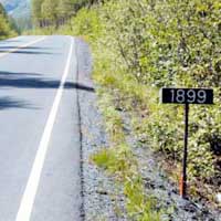
With the warming trend of the 1800s, Exit Glacier began to retreat from its 1815 maximum. Very slowly, the glacier retreated 230 feet (70 m) from 1815 to 1889, averaging about 3.1 ft/year (1 m/yr) (see Table 1). The glacier then retreated much more rapidly between 1889-1899, interspersed with periods of stagnation, which are marked by linear moraines (1889, 1891, 1894 and 1899). During this time, the glacier retreated 1680 ft (512 m), about 168 ft/yr (51 m/yr). The next fifteen years was a period of a slow but s teady retreat, as t he g lacier retreated only 42 ft/yr (13 m/yr). In the years between 1914 and 1917, Exit Glacier experienced its most rapid retreat. In just 3 years, the glacier retreated 908 ft (277 m) or almost a foot per day. From 1917 to 1973, Exit Glacier continued to retreat with periods of slow to moderate retreat. There were five periods of retreat, with the ice melting fastest between 1961 and 1968 (115 ft/yr or 35 m/yr) During the retreat of Exit Glacier from its Little Ice Age maximum in 1815 until recent times, the glacier has left a series of more than 11 moraines and retreated more than 1.25 miles (2 km). The glacier had an average retreat of roughly 6/10 of a mile each century or one kilometer each century. Discussion
Visitors to the park can imagine the power of glacial forces by seeing firsthand the effects of the glacier. As visitors proceed up the valley towards the glacier, they are also taking a trip through time. Interpretative signs show when the glacier retreated past points along the way. Similar to hikers in the Grand Canyon, visitors can take a walk through history and experience geologic time in a way no text can ever provide. More information can be found on the National Park Service website //www.nps.gov/kefj. References Crossen, K. 1997. Neoglacial fluctuations of terrestrial, tidewater, and calving lacustrine glaciers, Blackstone - Spencer Ice Complex, Kenai Mountains, Alaska. Ph.D. thesis, University of Washington. Cusick, Joel. 2001. Foliar nutrients in black cottonwood and Sitka alder along a soil chronosequence at Exit Glacier, Kenai Fjords National Park, Alaska. Masters thesis, University of Alaska, Anchorage. More general information on Kenai Fjords National Park is available at: Kenai Fjords National Park We would like to thank the NPS for the above information.
Backcountry Safaris is a member of the following trade and travel organizations: |


 Did You Know?
 |
Alaska Sea Kayaking Trips Anchorage, Alaska |
Alaska Raft Trips Denali Park Nenana River Rafting 4 Day Chulitna River Rafting 7 Day Lake Creek Rafting Arctic Wildlife Refuge Rafting Trip Denali Natioanl Park Denali Park Tours and Activities Denali Park Bus Tours Denali Park Dog Mushing Tour Denali 4X4 ATV Trips 3- 5 Day Exclusive Denali Park Tour Denali Park Transportation Denali Hotels and Lodging Alaska Railroad Alaska Railroad Passenger Service Alaska Railroad, Train Day Tours Alaska Railroad, Multi-day Tour Packages Denali Train, Denali Star Train Seward Train, Coastal Classic Train Glacier Discovery Train Whittier Train, Portage Spencer Grandview Goldstar Train, Alaska Railroad Gold Star Dome Kenai Fjords Train Fairbanks Train Aurora Winter Train, Anchorage-Fairbanks Hurricane Turn Train, Talkeetna Flag Stop Train Alaska Railroad History Alaska Bus Passenger Service Denali - Anchorage Bus Denali - Seward Bus Denali - Talkeetna Bus Denali - Whittier Bus Seward - Anchorage Bus Homer - Anchorage Bus Talkeetna - Anchorage Bus Motor Coach Tours Escorted Motor Coach Tours Arctic National Wildlife Refuge Kongakut River 10 Day ANWR Rafting Trip Seward, Alaska Seward, Alaska Tours Seward Dog Sled Trips |
Seward Water Taxi Fairbanks, Alaska Tours |
Alaska Fishing Halibut Fishing Seward Salmon Fishing Seward Halibut fishing Homer Kenai River Fishing King Salmon Fishing Kenai River Float Fishing Trips Raft Fishing Trips Alaska Cruises Small Ship Alaska Cruise Holland America Alaska Cruises Princess Alaska Cruises Disney Alaska Cruises Alaska Cruise Specials Alaska Day Cruises Kenai Fjords Glacier Cruises Prince William Sound Glacier Cruises Pre-Cruise Vacations Packages Post-Cruise Vacation Packages Cruise Land Tours Cruise Lines Shore Excursion Alaska Winter Vacations Alaska Snow Machine Tours Anchorage Fur Rondy, Anchorage Winter Festival Iditarod Dog Mushing Race Chena Hot Springs Resort Northern Lights Tours Alaska Railroad Fairbanks tour Alaska Hotels and Lodging Anchorage, Alaska Hotels Seward, Alaska Hotels Seward B&B and cabins Fairbanks, Alaska Hotels Denali Park Hotels Denali Cabins Denali Backcountry Lodges Denali Lodges Homer, Alaska Hotels Princess Hotels & Resorts Princess Lodges Vancouver, Canada Hotels |