


|
We offer Alaska raft trips that offer scenic views, wildlife viewing, fishing, and whitewater.
Custom group Alaska rafting adventures are available on request. If have interested in something special or participating in an exploratory expedition, please contact us with your ideals or to see what plans are being made.
Kongakut River - 10 day Arctic National Wildlife Refuge Rafting Safari. Explore Alaska's remote Arctic National Wildlife Refuge (ANWR) by raft on the "river of caribou". Our trip coincides with the annual migration of the 130,000-strong Porcupine caribou herd and passes through some of the world's most pristine wilderness.
Lake Creek - 7 day Whitewater Rafting and Fishing Adventure. Our favorite fly-in wilderness adventure river, great combination exciting whitewater and great Alaska fishing. Lake Creek offers almost continuous Class II/III whitewater with a few Class IV rapids, five species of salmon, rainbow trout and arctic grayling.
Chulitna River - 4 day Denali Raft Adventure. An excellent family adventure and sampling of Alaska's best wilderness and geography at a casual pace. We travel through Denali State Park, upper Susitna Valley and take out near Trapper Creek, a historic gold mining town. |
|
|
|
 |
Kenai Fjords National Park Cultural Resources
 The Alaska National Interest Lands Conservation Act (ANILCA) of 1980 created Kenai Fjords National Park. The act directs that the park "be managed for the following purposes, among others: To maintain unimpaired the scenic and environmental integrity of the Harding icefield, its outflowing glaciers, and coastal fjords and islands in their natural state; and to protect harbor seals, steller sea lions, other Kenai Fjords marine mammals, and marine and other birds, and to maintain their hauling and breeding areas in their natural state, free of human activity which is disruptive to their natural processes. The Alaska National Interest Lands Conservation Act (ANILCA) of 1980 created Kenai Fjords National Park. The act directs that the park "be managed for the following purposes, among others: To maintain unimpaired the scenic and environmental integrity of the Harding icefield, its outflowing glaciers, and coastal fjords and islands in their natural state; and to protect harbor seals, steller sea lions, other Kenai Fjords marine mammals, and marine and other birds, and to maintain their hauling and breeding areas in their natural state, free of human activity which is disruptive to their natural processes.
Although cultural resources are not specifically cited in the implementing language, they are part of the NPS management mandate. In addition, in order to properly manage and interpret the natural environment, animal populations and plant communities of this unit it is necessary to develop a diachronic perspective. Humans have been part of this ecosystem and interacting with it for at least 8000 years. A basic inventory and evaluation of the archeological resources of Kenai Fjords National Park will provide essential information about human presence and activities of the centuries.
Land Ownership
Of a total of 671,000 acres in the national park, 529,000 acres are federally-owned. The state of Alaska has about 19,000 acres. There are several native allotments and cemetery/historical (14h1) sites with the park. Local Native groups have under application 122,000 acres. The Port Graham and English Bay Village Corporations have applied for the majority of those acres, including 8 14h1 sites. In addition, there are 160 acres of unpatented mining claims within the park. Most of the land under application is located along the coastal parts of the park.
Environment
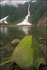
Kenai Fjords National Park occupies the southeastern portion of the Kenai Peninsula in the southcentral part of Alaska. The Peninsula is located within the Kenai-Chugach mountains physiographic province, a division of the Pacific Mountain System. The park lies completely within the Kenai Mountains topographic unit. This unit covers an area of 1860 square kilometers (760 square miles) and elevations lie generally between 1220 and 1600 meters ASL. The predominant bedrock is graywacke and shale. Other common rock types are greenstone, tuff, and chert. The region was uplifted and eroded at various times during the Tertiary and Quaternary periods. Currently, fluvial and glacial deposits overlie bedrock in all areas except the high, steep slopes. Soils of the region are characteristically shallow, poorly developed, very gravelly, and acidic.
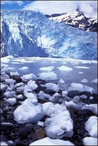
The park encompasses nearly 65% of the Harding Icefield, plus the fjords, islands and peninsulas of the Kenai coast. The icefield is a remnant of the Ice Age - a surviving expanse of Pleistocene glaciation. Numerous valley glaciers flow outward from the icefield, some reaching the sea, others ending in lakes or on bare ground. Along the coast glaciers have cut deep bays into the mountainous shoreline, creating a series of deep fjords. Heavy vegetation of almost rain forest proportions covers the tops of cliffs rising a hundred feet or more above the ocean. The coastal area has abundant aquatic life, including seals sea lions, sea otters and migrating whales. Sea birds in large numbers occupy the coastal cliffs in summer. Seasonally, littoral resources such a shellfish are easily accessible. Salmon runs are also abundant. These resources proved attractive to prehistoric and historic groups of people.
 Kenai Fjords National Park is about 100 miles south of Anchorage. Access is by highway, air , rail and water. Park headquarters is in the coastal city of Seward, which is just outside the northeastern corner of the park. The western coast of the Gulf of Alaska forms the coastal (eastern) boundary of the park. Kenai Fjords National Park is about 100 miles south of Anchorage. Access is by highway, air , rail and water. Park headquarters is in the coastal city of Seward, which is just outside the northeastern corner of the park. The western coast of the Gulf of Alaska forms the coastal (eastern) boundary of the park.
There are four major ecosystems within the park. The Arctic-Alpine zone is above the tree line. Sedges, grasses, willows and other dwarf plants are the dominant vegetation. An alder belt, sometimes extending down to sea level, usually separates this zone from other below tree line. Interior valleys comprise the Hudsonian zone, which is a Sitka spruce and birch forest. Hemlock, bunchberry, mountain cranberry, and devil's club are also common. Along the coast the Hudsonian zone merges with the Canadian zone, which may be characterized as a transcontinental coniferous forest, here dominated by Sitka spruce. Vegetation here is more lush than inland and includes such plants as bluejoint reedgrass, devil's club, salmonberry, and skunk cabbage. The coastal marine system is comprised of islands, beaches and cliffs. The associated intertidal zone is a rich one, including large stands of kelp forest and eelgrass.
Archeological Resources
Very little is known about the prehistory of Kenai Fjords National Park, partly because very little archeological inventory has been done there until recently and partly because the terrain and heavy vegetation make site discovery difficult. In addition, recent geological history complicates the process of searching for intact coastal sites. For example, the archeological records of many inner fjord areas have probably been erased by glacial advances during the Little ice Age (1100-1850 AD), and tectonic subduction of the Pacific Plate has resulted in ongoing coastal subsidence, exposing shoreline sites to erosion and raising sea level to cover them. There is evidence from Aialik Bay indicating that a major earthquake in about 1090 AD caused almost two meters of subsidence along the Kenai Fjords coast. The 1964 earthquake also caused subsidence. However, the Exxon Valdez oil spill did impact the Kenai Fjords National Park coastline and some exploratory and assessment work was undertaken at that time. As a followup to that work, an archeological inventory, funded as part of the SAIP program, was undertaken for the coastal area. The data from this survey are now being analyzed.
A brief overview based on chronologies from surrounding areas will provide some perspective. Kodiak Island contains the earliest evidence of a coastal-marine adaptation in the area. These early finds have been grouped into the first phase of an archeological tradition known as Ocean Bay, which seems to have been focused on Kodiak and the nearby Alaska Peninsula. This Ocean Bay I culture has been dated to approximately 6500 BP. Ocean Bay II, dated to between 4500 and 3900 years age, differs primarily from the preceding culture in its emphasis on ground and polished slate over flaked stone. The assemblages from this phase also seem to represent a diversification in resources bases and subsistence strategies. Open water sea mammal hunting, riverine fishing, and inland caribou hunting are all indicated.
For the time period between 3000 and approximately 800 years ago, the most complete cultural history comes from Kachemak Bay on the west side of the Kenai Peninsula. It seems to have been related to the Ocean Bay materials but with an increase in the variety of both of the polished stone tools and bone implements for sea mammal hunting. It extended over time from Kachemak Bay to Cook Inlet, Prince William Sound (Kachemak Bay III) and down to Kodiak Island. Kachemak Bay I has been found only on Yukon Island and was dated to about 2800 BP. Kachemak Bay II, radiocarbon dated to 1700 BP, has been recognized in Prince William Sound and as far inland on the Kenai Peninsula as Skilak and Kenai lakes.
As far as 3500 years ago, Norton influence affected Cook Inlet, the Kenai Peninsula, and Prince William sound. The Norton tradition is clearly an Eskimo culture but seems to represent here an adaptation to an interior and riverine environment and an increased emphasis on fishing for subsistence. Then, about 1000 years go, another wave of Eskimo culture, in the form of the influential Thule tradition, can be discerned in the archeological record of the area. Thule reinforced already existing cultural patterns throughout the area and brought an increased emphasis on sea mammal hunting. Beginning about 1100 AD, when Thule is first recognized in the area, coastal southcentral Alaska gradually developed into the local cultures that were present at the time of contact. About 900 years ago, the Koniag phase appeared on Kodiak Island. This was a widely influential group which was directly ancestral to modern Koniag Eskimos.
Historical Aspects
 Captain Vitus Bering, in 1741, was the first known European to see the Kenai Peninsula. Captain James Cook made the European discovery of Cook inlet in 1778. After Cook's visit the area became the scene of bitter competition among rival fur companies for the natural resources of Russian America. Alexander Baranof named Resurrection Bay in 1792, finding it a welcome refuge from Pacific storms. In 1793 Baranof selected a site on the west side of Resurrection Bay for a ship building port. At least three major vessels were built at this port, named Voskresenski Harbor, before its abandonment around 1796. The location of this site was lost and it has not yet been rediscovered. The area was controlled by the Russians until the United States purchase. By that time, trading posts had been established at English Bay, Kenai, Tyonek and Iliamna. The first American settlement in the Seward area was in 1884, by William Lowell. The railroad connecting Seward to the Interior was conceived in 1898 and completed by 1915. Captain Vitus Bering, in 1741, was the first known European to see the Kenai Peninsula. Captain James Cook made the European discovery of Cook inlet in 1778. After Cook's visit the area became the scene of bitter competition among rival fur companies for the natural resources of Russian America. Alexander Baranof named Resurrection Bay in 1792, finding it a welcome refuge from Pacific storms. In 1793 Baranof selected a site on the west side of Resurrection Bay for a ship building port. At least three major vessels were built at this port, named Voskresenski Harbor, before its abandonment around 1796. The location of this site was lost and it has not yet been rediscovered. The area was controlled by the Russians until the United States purchase. By that time, trading posts had been established at English Bay, Kenai, Tyonek and Iliamna. The first American settlement in the Seward area was in 1884, by William Lowell. The railroad connecting Seward to the Interior was conceived in 1898 and completed by 1915.
At present, there are three unpatented mining claims within the park. These historic sites have been mapped by the Cultural Resources Mining Inventory program of the NPS. Four other historic era sites (SEW-01 - 04), were found in the Resurrection River valley in 1983.
Ethnographic Aspects
At contact, the aboriginal inhabitants of the area that is now Kenai Fjords National Park were most probably Pacific Eskimos with Tanaina (Dena'ina) Athapaskan groups as near neighbors. Of the Eskimos, the Chugachigmiut (now Chugach) lived in and adjacent to Prince William sound; the Unagalakmiut occupied Kayak Island and the adjacent mainland; the Unixkugmiut resided on the south coast of the Kenai Peninsula.. Little recorded history exists relating to the Ugalakmiut and the Unixkugmiut, but their culture was apparently quite similar to that of the more populous Chugach. The Chugach people represent the extreme extension of Alaskan Eskimo culture in a southeasterly direction. Archeological studies indicate that the Chugach existed with little cultural change in this region for at least 500 years prior to the European discovery of Alaska.
The Unixkugmiut were considered a separate people by the Chugach. Their territory seems to have extended from the vicinity of Puget Bay, at the western end of Prince William Sound, to Cook inlet, including Kachemak Bay. The Unixkugmiut probably occupied most of Cook inlet during the period of Kachemak Bay III culture. Later, they seem to have been replaced by the expanding Tanaina people over most of their territory. The National Park now lies within the boundaries of the Chugach Alaska Corporation.
 After contact, major disruptions in Native life and culture were caused by epidemics, missionization and the introduction of commercial fishing and hunting (with the concomitant shifts in resource availability). The last Native settlement on the south coast, at Aialik Bay, was probably abandoned about 1880. It appears that the inhabitants migrated to Alexandrovski, on English Bay, which was originally a Russian Port established in 1785, and is now the village of English Bay. Natives also moved to Port Graham, where the Russians began mining coal in 1855 and where a commercial cannery was opened in 1909. After contact, major disruptions in Native life and culture were caused by epidemics, missionization and the introduction of commercial fishing and hunting (with the concomitant shifts in resource availability). The last Native settlement on the south coast, at Aialik Bay, was probably abandoned about 1880. It appears that the inhabitants migrated to Alexandrovski, on English Bay, which was originally a Russian Port established in 1785, and is now the village of English Bay. Natives also moved to Port Graham, where the Russians began mining coal in 1855 and where a commercial cannery was opened in 1909.
More general information on Kenai Fjords National Park is available at:
Kenai Fjords National Park
We would like to thank the NPS for the above information.
 |
Backcountry Safaris
P.O. Box 1397 Seward, Alaska USA 99664
1-907-205-5900 • Fax 1-907-205-5902
 |
Backcountry Safaris is a member of the following trade and travel organizations:
 | |
|
|
Kenai Fjords Maps |
|
|
|
Kenai Fjords Related Links |
|
|
Kenai Fjords Wildlife |
|
|
Kenai Fjords Birds |
|
|
Suggested Reading |
|
|
Kenai Fjords Weather |
|
|
Current Seward, AK Weather |
|
 Did You Know? Did You Know?
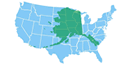
With 570,374 square miles, Alaska is twice the size of Texas and 1/5 the size of the rest of the United States. It stretches 2,400 miles east-to-west and 1,420 miles north-to-south. Its 6,640-mile coastline is 50 percent longer than the combined east and west coasts of the United States. |
|