


|
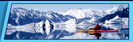
The Harding Icefield Kenai Fjords National Park is a land dominated by glaciers, massive rivers of ice that flow out from the Harding Icefield. Today nearly 56 percent of the park is covered by ice, but all of this land was once buried beneath the ice and still bears its influence. The dramatic coastal fjords and valleys of the park reveal a long history of glaciation. Naming the Ice
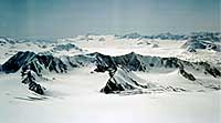
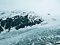
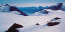
Over 30 glaciers of different size and type flow outward from the Harding Icefield. Some of these glaciers are tidewater (Aialik Glacier) or terminate in lakes (Skilak Glacier), and some end on land (Exit Glacier). Icefields are sensitive to climate change, growing and melting in response to changes in temperature and snowfall. Icefields also exert their own influence on local and global climate, changing pressure systems and wind directions, serving to keep adjacent land and water cold. Climate Change Past and Present Scientists studying glacial geology and past climates recognize that the last two and a half million years of Earth’s history fluctuated periodically between cold and warm conditions. Studies of glacial deposits on land indicate at least four major periods of glaciation. Evidence from deep-sea cores suggests that a dozen major glaciations may have occurred during the Pleistocene Epoch. Most scientists accept the Milankovitch theory (see climate change section of this manual) of orbital forcing—that cyclical changes in the Earth’s orbit around the sun are a principal cause of the ice age and long-term changes in the Earth’s climate. Recent scientific studies are documenting significant short-term changes in Alaska glaciers and the Harding Icefield. A National Park Service (NPS) study using aerial photographs and satellite imagery measured a three percent reduction in the surface area of the Harding Icefield over a period of 16 years. The NPS plans to repeat this study every ten years to monitor further changes. In 2004, the NPS installed an automated weather station at 4,200 feet on a nunatak in the northeastern part of the Harding Icefield (Figure 2). The weather station records and transmits weather observations (temperature, wind speed and direction, relative humidity, precipitation, snow depth, and solar radiation) hourly. Current weather observations and summary reports can be viewed at the Western Region Climate Center’s website: www.wrcc.dri.edu/cgi-bin/ rawMAIN.pl?akAHAR During the first three full years of operation, the lowest observed temperature was -21 degrees F, the highest observed temperature was 68 degrees F, and the maximum observed sustained wind gust was 117 miles per hour. The Lure of the Icefield
Before the early 1920s, local residents paid little attention to the huge icefield in the mountain range behind the town. Alutiiq and Dena’ina Natives were no doubt familiar with the ice and had accessed it, but there is no record of any attempted crossing until 1936. Yule Kilcher, a 27-year-old Swiss immigrant, had heard of the icefield and seen its edge from the steamer that had dropped him off in Seward. Needing to get to Homer and unwilling to wait for another steamer, Kilcher decided to cross the Harding. He headed up Lowell Creek but returned within a week, having learned a crossing like this would be more of an expedition than a hike. The first known crossing of the icefield occurred in 1940 when two Alaskans, Eugene “Coho” Smith and Don Rising, crossed from Bear Glacier to Tustumena Lake. In the mid-1960s, two parties attempted but failed to make the crossing. In 1968, a mountaineering party departed Homer on horseback, traveled up Chernof Glacier on foot and skis, and completed the first ascent of Truuli Peak, the highest point on the Kenai Peninsula. Part of this group, including Yule Kilcher, continued across the Harding Icefield and skied down Exit Glacier. The trip took eight days. Notable recent explorations include a 14-hour solo crossing of the icefield from Skilak Glacier to Chernof Glacier and a kite-skiing expedition from Exit Glacier to Grewingk Glacier. Ice as Far as the Eye Can See In 1980, the founding legislation for Kenai Fjords National Park included a segment to protect and preserve the Harding Icefield and its out-flowing glaciers. Today, during the warmth of the mid-summer season, many people climb the Harding Icefield Trail to see the ice firsthand. At the top, the view is unlike any other: Mountain peaks enshrouded with ice stretch off into the distance and many must be tempted to come back someday, like Kilcher, and go further. More general information on Kenai Fjords National Park is available at: Kenai Fjords National Park We would like to thank the NPS for the above information.
Backcountry Safaris is a member of the following trade and travel organizations: |


 Did You Know?
 |
Alaska Sea Kayaking Trips Anchorage, Alaska |
Alaska Raft Trips Denali Park Nenana River Rafting 4 Day Chulitna River Rafting 7 Day Lake Creek Rafting Arctic Wildlife Refuge Rafting Trip Denali Natioanl Park Denali Park Tours and Activities Denali Park Bus Tours Denali Park Dog Mushing Tour Denali 4X4 ATV Trips 3- 5 Day Exclusive Denali Park Tour Denali Park Transportation Denali Hotels and Lodging Alaska Railroad Alaska Railroad Passenger Service Alaska Railroad, Train Day Tours Alaska Railroad, Multi-day Tour Packages Denali Train, Denali Star Train Seward Train, Coastal Classic Train Glacier Discovery Train Whittier Train, Portage Spencer Grandview Goldstar Train, Alaska Railroad Gold Star Dome Kenai Fjords Train Fairbanks Train Aurora Winter Train, Anchorage-Fairbanks Hurricane Turn Train, Talkeetna Flag Stop Train Alaska Railroad History Alaska Bus Passenger Service Denali - Anchorage Bus Denali - Seward Bus Denali - Talkeetna Bus Denali - Whittier Bus Seward - Anchorage Bus Homer - Anchorage Bus Talkeetna - Anchorage Bus Motor Coach Tours Escorted Motor Coach Tours Arctic National Wildlife Refuge Kongakut River 10 Day ANWR Rafting Trip Seward, Alaska Seward, Alaska Tours Seward Dog Sled Trips |
Seward Water Taxi Fairbanks, Alaska Tours |
Alaska Fishing Halibut Fishing Seward Salmon Fishing Seward Halibut fishing Homer Kenai River Fishing King Salmon Fishing Kenai River Float Fishing Trips Raft Fishing Trips Alaska Cruises Small Ship Alaska Cruise Holland America Alaska Cruises Princess Alaska Cruises Disney Alaska Cruises Alaska Cruise Specials Alaska Day Cruises Kenai Fjords Glacier Cruises Prince William Sound Glacier Cruises Pre-Cruise Vacations Packages Post-Cruise Vacation Packages Cruise Land Tours Cruise Lines Shore Excursion Alaska Winter Vacations Alaska Snow Machine Tours Anchorage Fur Rondy, Anchorage Winter Festival Iditarod Dog Mushing Race Chena Hot Springs Resort Northern Lights Tours Alaska Railroad Fairbanks tour Alaska Hotels and Lodging Anchorage, Alaska Hotels Seward, Alaska Hotels Seward B&B and cabins Fairbanks, Alaska Hotels Denali Park Hotels Denali Cabins Denali Backcountry Lodges Denali Lodges Homer, Alaska Hotels Princess Hotels & Resorts Princess Lodges Vancouver, Canada Hotels |