


|
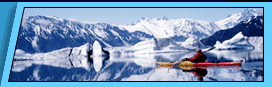
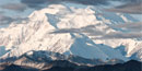
Alaska Railroad Route Map And Points Of Interest Train Passenger Service — Alaska Train Day Tours — Alaska Train Vacations 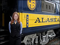 The Alaska Railroad is America's only full-service railroad, offering both freight and passenger service year-round. The Alaska Railroad route, including branch lines and sidings, covers more than 500 miles. The line runs from tidewater at Whittier and Seward to Anchorage, the state's largest city, and through the heart of Alaska to Fairbanks. The map below is a guide to some of the scenery and significant points you can see along your trip. The Alaska Railroad is America's only full-service railroad, offering both freight and passenger service year-round. The Alaska Railroad route, including branch lines and sidings, covers more than 500 miles. The line runs from tidewater at Whittier and Seward to Anchorage, the state's largest city, and through the heart of Alaska to Fairbanks. The map below is a guide to some of the scenery and significant points you can see along your trip.Mile 470.3 Fairbanks - Alaska's second largest city, Fairbanks began as a trading post and mining town in 1901. It is the northern terminus of the Alaska Railroad and southern terminus of the famous Haul Road to the North Slope oil fields. Mile 467.1 College - Location of the world’s northernmost institution of higher education - the University of Alaska Fairbanks. Mile 466.0 University Farm - A working farm and experimental station on the University of Alaska Fairbanks campus, the facility produces dairy, meat and vegetable products. 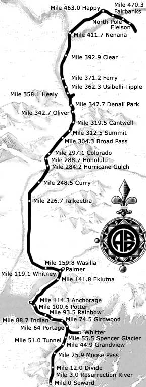 Mile 463.0 Happy - Once the beginning of a narrow-gauge railroad serving remote mining districts to the north, the line was abandoned as roads were built. Mile 463.0 Happy - Once the beginning of a narrow-gauge railroad serving remote mining districts to the north, the line was abandoned as roads were built.Mile 413.7 Mears Memorial Bridge - The 700-foot steel structure, one of the world's longest single-span bridges, marks the completion of the Alaska Railroad and was dedicated by President Warren G. Harding in 1923. Watch below for Athabascan fish wheels in the Tanana River. Mile 411.7 Nenana - Originally an Athabascan village, Nenana is located on the south bank of the Tanana River at its confluence with the Nenana River. It was a railroad construction camp in the early 1900s and today serves as a hub for barge operations, serving communities up and down the Yukon River and connecting waterways for hundreds of miles. Mile 392.9 Clear - Nearby is an air base and early warning radar site. Mile 71.2 Ferry - This route across the Nenana River accesses historic gold fields to the east. Mile 362.3 Usibell Tipple - The tipple is a covered loading facility with a railroad track running through the center for coal loading. The coal is mined across the river and transported to the tipple by conveyor. Mile 358.1 Healy - Start of a 4-mile branch line serving nearby coal mines. Watch for dark coal seams in the exposed rocks to the east. The coal fuels electric power plants in the Interior and is exported to Korea. Mile 347.7 Denali Park - Entrance to Denali National Park and Preserve. Riley Creek Bridge is the railroad's second highest. Mile 342.7 Oliver - The site was named for former Railroad Roadmaster Thomas Oliver. Mile 319.5 Cantwell - A small settlement and starting point of the Valdez Creek gold mining district. Mile 312.5 Summit - The summit of the Continental Divide is at 2,363 feet and is the lowest rail pass in the Rocky Mountain chain. Summit Lake eventually drains both into the Pacific and the Bering Sea. 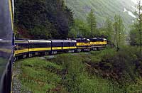 Mile 304.3 Broad Pass - Southern end of the broad, treeless pass that is the lowest traveled pass in the Rocky Mountain chain from Mexico to Alaska. Mile 304.3 Broad Pass - Southern end of the broad, treeless pass that is the lowest traveled pass in the Rocky Mountain chain from Mexico to Alaska.Mile 297.1 Colorado - Access route to once-closed gold mines that are becoming active again. Mile 288.7 Honolulu - Halfway point between Anchorage and Fairbanks, the area has a very active beaver population and dams can be seen along the tracks. Mile 284.2 Hurricane Gulch - One of the line's best photo vantage points, the bridge spans 918 feet, some 296 feet above the creek. Mile 279.0 Scenic Viewpoint - Mount McKinley, otherwise known as "Denali" or "the Great One," is only 46 miles from this point. Mile 248.5 Curry - Today a ghost town, Curry recalls a bygone era when a rail trip from Anchorage to Fairbanks involved two days of travel and an overnight stay in the now defunct hotel. 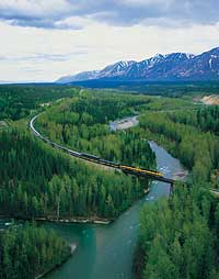 Mile 226.7 Talkeetna - Base station for assaults on Mount McKinley, Talkeetna began as a trapping and mining outpost. Today it's a world-class destination for salmon fishing, rafting and boating excursions, and a wide variety of other Alaskan adventures. Mile 226.7 Talkeetna - Base station for assaults on Mount McKinley, Talkeetna began as a trapping and mining outpost. Today it's a world-class destination for salmon fishing, rafting and boating excursions, and a wide variety of other Alaskan adventures.Mile 224.3 Scenic Viewpoint - Mount McKinley, 20,320 feet; Mount Hunter, 14,960 feet; Mount Foraker, 17,000 feet; Mount Russell, 11,600 feet; and Mount Dall, 9,000 feet, all are visible from this panoramic vantage point. This is the confluence of three major rivers, the Talkeetna, Chulitna and Susitna. Mile 180.7 Nancy - Nancy Lake State Recreation Area, a chain of lakes and streams, lies to the west. Mile 159.8 Wasilla - The headquarters of the famed Iditarod Sled Dog Race. Mile 150.7 Matanuska - Home of world-record vegetables and the center of agriculture for Southcentral Alaska, the Valley includes Palmer and surrounding communities. It was settled by "colonists" from the Lower 48 in the early 1930s. Mile 141.8 Eklutna - Location of Alaska's earliest hydroelectric project and the source of fresh water for Anchorage. Named for the nearby Athabascan Indian village of Eklutna, the village is also the site of a traditional cemetery and a Russian Orthodox church. Mile 119.1 Whitney - The rail line passes through Elmendorf Air Force Base where fighter jets can frequently be seen taking off or landing. 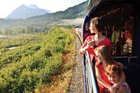 Mile 114.3 Anchorage - Perched on the Knik Arm of Cook Inlet and framed by the Chugach Mountain Range, Anchorage began as a railroad construction base and saw boom times through both World War I and II as a military staging city. Anchorage has grown into Alaska's center for finance and industry. It is the state's largest city, with more than 250,000 people. Mile 114.3 Anchorage - Perched on the Knik Arm of Cook Inlet and framed by the Chugach Mountain Range, Anchorage began as a railroad construction base and saw boom times through both World War I and II as a military staging city. Anchorage has grown into Alaska's center for finance and industry. It is the state's largest city, with more than 250,000 people.Mile 100.6 Potter - The historic Potter section house and Potter Marsh Wildlife Viewing Area mark the junction of Cook Inlet and Turnagain Arm, so named when Captain Cook's search up the arm for the Northwest Passage ended when he had to "turn again." Watch for the bore tide, a six-foot wall of water that can rush into or out of the arm during the area's huge tide changes — which can range as much as 30 feet. Mile 88.7 Indian - Home of local craftsmen and artisans, Indian offers a panoramic view of Turnagain Arm and the Kenai and Chugach mountains. Mile 74.5 Girdwood - Alaska's finest ski resort, condominiums, chalets, first class accommodations and restaurants are located at the base of Mount Alyeska. Whittier - A 12.4-mile branch line connects Portage and Whittier. The Anton Anderson Memorial Tunnel to Whittier is the longest highway tunnel in North America (13,300 feet or 2.5 miles). It is also the longest combined vehicle-railroad use tunnel in North America. 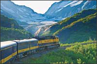 Mile 64.0 Portage - Devastated by the 1964 earthquake, the old town of Portage is all but gone. Dead trees stand in silent testimony to the power of the quake, which flooded the town and dropped the surrounding land 10 to 12 feet. Mile 64.0 Portage - Devastated by the 1964 earthquake, the old town of Portage is all but gone. Dead trees stand in silent testimony to the power of the quake, which flooded the town and dropped the surrounding land 10 to 12 feet.Mile 53.7 Spencer Glacier - This magnificent wall of ice is less than a mile from the tracks. Mile 51.0 Tunnel - A section station today, this was once headquarters for the "Loop" an engineering marvel which allowed the tracks to cross over themselves on a wooden trestle as the trains wound through the canyon. Mile 48.2 Bartlett Glacier - Named in 1907 for Frank Bartlett, Alaska Central Railroad civil engineer, the glacier is visible just 800 feet away from the tracks. Deadman Glacier rises above. Mile 44.9 Grandview - Grandview is the staging area for special winter "ski trains" for cross-country skiing. 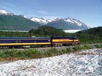 Mile 44.3 Trail Glacier - Great views of Trail Glacier, Trail Creek and Trail Canyon. Mile 44.3 Trail Glacier - Great views of Trail Glacier, Trail Creek and Trail Canyon.Mile 25.9 Moose Pass - This small settlement along Upper Trail Lake was once a railroad section station. Mile 25.7 Lower Trail Lake - The last in a trio, the lower lake drains into Kenai Lake. Mile 12.0 Divide - Summit of the first crossing of the Kenai Mountains. Mile 3.0 Resurrection River Mile 0.0 Seward - A year-round deep-water port, Seward is the gateway to Interior Alaska and is situated on Resurrection Bay's fertile salmon and halibut-filled waters. The town is named in honor of William H. Seward, who orchestrated the purchase of Alaska from the Russians in 1867.
Backcountry Safaris is a member of the following trade and travel organizations: |
|


 Did You Know?